Geological Marvels of Vermilion Cliffs National Monument
Vermilion Cliffs National Monument, located in northern Arizona along the Utah border, is a spectacular region known for its vibrant red rock formations, expansive plateaus, and deep canyons. Covering nearly 294,000 acres, it offers visitors a glimpse into some of the Southwest’s most rugged and unspoiled landscapes. Established in 2000 and managed by the U.S. Bureau of Land Management, the monument protects unique geological features like The Wave, White Pocket, and Paria Canyon, along with rich cultural and natural resources. It is an ideal destination for outdoor enthusiasts, educators, and anyone interested in exploring a remarkable and diverse environment.
Quick Facts & Official Data
- Location: Northern Coconino County, Arizona, right beneath the Utah border
- Area: 293,689 acres (118,852 hectares)
- Established: November 9, 2000, by presidential proclamation from President Bill Clinton
- Managing Agency: U.S. Bureau of Land Management (BLM), U.S. Department of the Interior
- Key Protected Areas: Paria Plateau, Vermilion Cliffs, Coyote Buttes (including The Wave), and Paria Canyon
- Elevation Range: 3,100 feet to 6,500 feet (944 to 1,981 meters)
- Nearest Cities: Page, Arizona and Kanab, Utah.

Geology: Million-Year Masterpiece
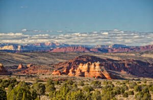
The heart of vermilion cliffs national monument is its geology. Steep, eroded escarpments composed of sandstone, siltstone, limestone, and shale rise as much as 3,000 feet (910 meters) above the valley floors. These sediment layers—formed millions of years ago—were exposed by wind and water, revealing hundreds of bands in stunning shades of red, orange, and purple. Mesas, buttes, and broad tablelands punctuate the region, interspersed with slot canyons and hidden springs. The Paria Plateau stretches northward above the cliffs, offering sweeping vistas that highlight Arizona’s extraordinary geological heritage.
The geology of Vermilion Cliffs National Monument is a testament to millions of years of geological processes that have shaped the region’s striking landscape. The cliffs themselves are composed primarily of sedimentary rock layers—including sandstone, siltstone, limestone, and shale—that date back to the Jurassic period, roughly 190 to 180 million years ago.
These sedimentary layers were originally deposited as ancient sand dunes, river deposits, and shallow seas, which over time were compressed and hardened into rock. Subsequent uplift of the Colorado Plateau exposed these formations, while erosion by wind and water sculpted the cliffs, canyons, mesas, and buttes seen today.
The vibrant red and orange colors result from iron oxide minerals within the sandstone, which oxidize to produce the characteristic “vermilion” hues. This geological history makes the monument an important site for studying sedimentology, stratigraphy, and the paleoenvironment of the ancient southwestern United States.
Iconic Features to Explore-
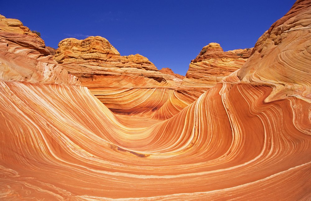
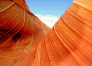
The Wave & Coyote Buttes– Perhaps the most internationally recognized formation is The Wave, located in Coyote Buttes North. Its surreal quartzite swirls look like a painting brought to life.
The Wave, located in Coyote Buttes North within Vermilion Cliffs National Monument, is renowned for its mesmerizing, undulating sandstone formations that display vibrant hues of red, orange, and yellow. This striking geological feature was formed by millions of years of wind and water erosion acting on Navajo Sandstone, creating its signature wave-like appearance.
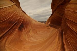
Access to The Wave is highly regulated to protect its delicate environment; the Bureau of Land Management requires visitors to obtain a permit through an advance online or daily lottery system. This strict permit process helps limit foot traffic and preserve the natural beauty and integrity of the area. Coyote Buttes North and South, both within the monument, also feature unique rock formations, with areas of colorful sandstone domes, fins, and arches.
Because of its rare and fragile landscape, The Wave is a coveted destination for hikers and photographers worldwide. Visitors are advised to prepare thoroughly, carry adequate water, use GPS for navigation, and adhere to Leave No Trace principles while exploring this extraordinary wilderness.
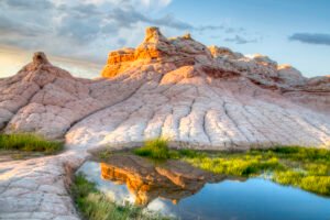
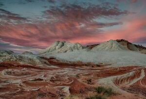
White Pocket
White Pocket is a distinctive area located within the Paria Plateau of Vermilion Cliffs National Monument. Known for its unique and colorful rock formations, White Pocket features swirling, textured sandstone that displays a range of white, red, and orange hues. These striking geological features were created by a combination of ancient sand dunes, mineral deposits, and erosion by wind and water over time.
Unlike Coyote Buttes North (home to The Wave), White Pocket currently does not require a permit to visit, making it more accessible for visitors. However, the route to White Pocket involves long stretches of deep sand and rugged terrain; the Bureau of Land Management advises that only high-clearance, four-wheel-drive vehicles should attempt the journey. The area is remote, with no developed facilities, so visitors should arrive well-prepared and practice Leave No Trace principles to protect its fragile environment.
White Pocket is popular among photographers, geologists, and outdoor enthusiasts for its exceptional scenery and the opportunity to observe rare geological processes in an undisturbed setting.
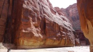
Paria Canyon & Buckskin Gulch
Beyond the plateaus are deep slot canyons like Paria and Buckskin Gulch. These winding formations provide unique opportunities for field studies in hydrology, ecology, and geology.

Paria Plateau and Vermilion Cliffs
The Vermilion Cliffs form a striking natural border along the southern and eastern edges of the monument, rising dramatically as steep sandstone escarpments that can reach heights of up to 3,000 feet. These cliffs reveal a complex geological history through their vividly colored layers of sandstone, siltstone, limestone, and shale, carved over millions of years by erosion and other natural forces.
Adjacent to these cliffs lies the Paria Plateau, a relatively flat and expansive area that extends northward from the cliff tops. This plateau offers an accessible terrain ideal for educational outings and scientific research, providing opportunities to study both geology and the evidence of ancient human activity. The Paria Plateau is also home to numerous archaeological sites, including petroglyphs and remnants of early Native American settlements, making it an important location for cultural and historical exploration within the monument.
Flora and Fauna: Living Laboratory
Vermilion Cliffs National Monument is home to a diverse range of flora and fauna, thriving within its unique desert and canyon ecosystems. The region supports more than twenty species of raptors, including majestic bald and golden eagles, peregrine falcons, and several hawk species that soar above the cliffs. Notably, the monument is a critical habitat for the endangered California condor, reintroduced here in 1996 due to the area's remote location and minimal human disturbance. This successful conservation effort continues to help stabilize and grow the condor population in the wild.
Large mammals such as desert bighorn sheep, pronghorn antelope, and elusive mountain lions roam the rugged terrain, while smaller mammals add to the monument’s biodiversity. The waterways within the monument sustain rare fish species like the flannelmouth sucker and the speckled dace, which are specially adapted to these desert streams.
Plant life is equally remarkable, with communities adapted to the harsh climate, including the threatened Welsh’s milkweed (Asclepias welshii). This rare plant grows predominantly on sand dunes within the monument and neighboring Utah, playing a vital role in stabilizing these fragile habitats.
Together, the diverse flora and fauna of Vermilion Cliffs National Monument create a living laboratory for ecological research and offer visitors ample opportunities for wildlife observation and nature study in a protected and pristine environment.
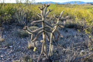

Streams carry rare fish like flannel mouth sucker and speckled dace. Flora includes the exclusive and threatened Welsh’s milkweed (Asclepias welshii), a plant found only in this monument and one adjacent Utah site.
Ancient Human History
The ancient human history of Vermilion Cliffs National Monument dates back approximately 12,000 years, making it a region rich in archaeological significance. Native American tribes, including the Ancestral Puebloans and later groups, inhabited this area, leaving behind numerous pueblos, granaries, ceremonial sites, and burial grounds. These ancient peoples skillfully adapted to the harsh desert environment, utilizing available resources for sustenance and cultural expression.
The monument contains one of the largest concentrations of rock art in the United States, including petroglyphs and pictographs that offer valuable insights into the spiritual and daily lives of these early inhabitants. Many of these rock art sites are believed to be among the oldest in North America, reflecting centuries of ongoing cultural traditions.
European exploration began in the late 18th century with Spanish missionaries and explorers like the Domínguez–Escalante expedition of 1776. In the 1860s, Mormon pioneers explored and settled parts of the area, building early infrastructure such as ferry crossings on the Colorado River. The historic Honeymoon Trail, which runs beneath the cliffs, was used by Mormon couples traveling to St. George, Utah, for marriage ceremonies and remains an important cultural landmark today.
This rich tapestry of human history intertwines with the monument’s natural beauty, offering an unparalleled opportunity for visitors to connect with both the past and the environment.
 Image credit: By Judson McCranie, CC BY-SA 3.0, Link
Modern Conservation & Visitor Experience
Since its creation, vermilion cliffs national monument has remained remarkably wild, with virtually no permanent inhabitants. Road access is limited, and the BLM maintains strict conservation protocols. Traveling here requires preparation for backcountry conditions—high-clearance vehicles, plenty of water, and navigation gear are recommended.
Permits: To access sensitive spots like The Wave and Paria Canyon overnight routes, apply through the official BLM mobile geo-fence system. This ensures visitor safety and minimizes ecological impact.
Visitor Safety: Cell service is sparse, and weather can change rapidly. Always notify someone of your travel plans and carry physical maps.
Educational Value
This monument is a living classroom for all ages. Teachers and students come to study geology, ecology, paleontology, ancient civilizations, and conservation management. Vermilion Cliffs National Monument offers a unique hands-on learning environment where visitors can observe diverse rock formations, rare plant and animal species, and well-preserved archaeological sites. Its protected status ensures ongoing research opportunities in environmental science and cultural preservation, making it an invaluable resource for education and scientific study
Tips for Educational Groups
- Contact BLM for guided ranger tours and approved field trip programs.
- Use monument maps for GPS and navigation lessons.
- Study ancient rock art with history or archaeology modules.
- Analyze plant and animal adaptations for biology research.
- Practice conservation ethics: leave no trace, respect habitats, report vandalism.
Suggested Activities
Hiking and Backpacking: Explore the Paria Plateau, canyons, and mesas. Follow marked trails when available.
Photography: Sunrise and sunset deliver vibrant colors. Use wide-angle lenses for landscapes, telephoto for wildlife.
Rock Art Exploration: Document petroglyphs and pueblos, always respecting and never touching the art.
Wildlife Spotting: Early mornings/late afternoons are best for spotting raptors and mammals.
Camping: Primitive sites only; bring all your supplies and pack out every item.
Whether you are a student, educator, researcher, or an outdoor enthusiast, Vermilion Cliffs National Monument offers an unparalleled opportunity to connect with one of Arizona’s most extraordinary natural and cultural landscapes. Spanning nearly 294,000 acres of vibrant cliffs, sweeping plateaus, and hidden slot canyons, this monument is a living classroom that showcases millions of years of geological history and centuries of human heritage. From the world-famous Wave formation in Coyote Buttes to the lesser-known but equally stunning White Pocket and Paria Plateau, each area invites exploration, discovery, and learning.
The monument’s rich biodiversity, including the reintroduced California condor and rare plant species, highlights the importance of ongoing conservation efforts led by the U.S. Bureau of Land Management. Its archaeological sites, ancient petroglyphs, and historic trails tell stories of Native American cultures as well as early explorers who shaped the region’s history. Visitors to Vermilion Cliffs National Monument can expect breathtaking scenery, challenging adventures, and valuable educational experiences—all while adhering to responsible travel practices that protect this fragile environment.
Plan your visit carefully, respect permit requirements for sensitive areas like the Wave, and prepare for the remote conditions. By discovering and preserving the natural wonders of Vermilion Cliffs National Monument, you become part of an important legacy, ensuring this unique gem remains protected for generations to come. Experience the magic, learn deeply, and be inspired by Arizona’s spectacular Vermilion Cliffs National Monument.
For more historical monuments, click on the link below👇
The 8 Wonders of the World: Epic History & Iconic Monuments
50 important Architectural Monuments of India With images